Spatial Distribution of Urban Tree Canopy in Private Residential Property in Jakarta Bay Reclamation using Google Earth Engine Cloud Computing

Penulis

  • Fajar Raihan Undergraduate Student, Department of Silviculture, Faculty of Forestry and Environment, IPB University, Bogor Regency 16680, Indonesia https://orcid.org/0009-0004-9222-0808
  • Lenny Eka Nurhawaillah Undergraduate Student, Department of Forest Management, Faculty of Forestry and Environment, IPB University, Bogor Regency 16680, Indonesia
  • Rahmat Asy'Ari SSRS EarthInformatics Labs, SSRS Institute - SSRS Group, Bogor Indonesia https://orcid.org/0000-0001-7867-2251
  • Oghi Risky Pratama Undergraduate Student, Department of Agronomy and Horticulture, Faculty of Agriculture, IPB University, Bogor Regency 16680, Indonesia
  • Winda Beatrix Alamako Undergraduate Student, Department of Forest Management, Faculty of Forestry and Environment, IPB University, Bogor Regency 16680, Indonesia
  • Nihawa Hajar Pudjawati Undergraduate Student, Department of Soil Science and Land Resource, Faculty of Agriculture, IPB University, Bogor Regency 16680, Indonesia
  • Rian Saputra Undergraduate Student, Department of Silviculture, Faculty of Forestry and Environment, IPB University, IPB Dramaga Campus, Bogor Regency 16680, Indonesia
  • Salsa Fauziyyah Adni Undergraduate Student, Department of Silviculture, Faculty of Forestry and Environment, IPB University, IPB Dramaga Campus, Bogor Regency 16680, Indonesia
  • Neviaty Putri Zamani Center for Transdisciplinary and Sustainability Sciences, IPB University, Bogor Regency, Indonesia
  • Rahmat Pramulya Research Center for Low Carbon Development, University of Teuku Umar (UTU), West Aceh Regency, Indonesia
  • Yudi Setiawan Center for Environmental Research, IPB University, Bogor Regency, Indonesia https://orcid.org/0000-0002-1482-1905

Kata Kunci:

Cloud Computing, Google Earth Engine, Jakarta Bay Reclamation, Sentinel-2 MSI

Abstrak

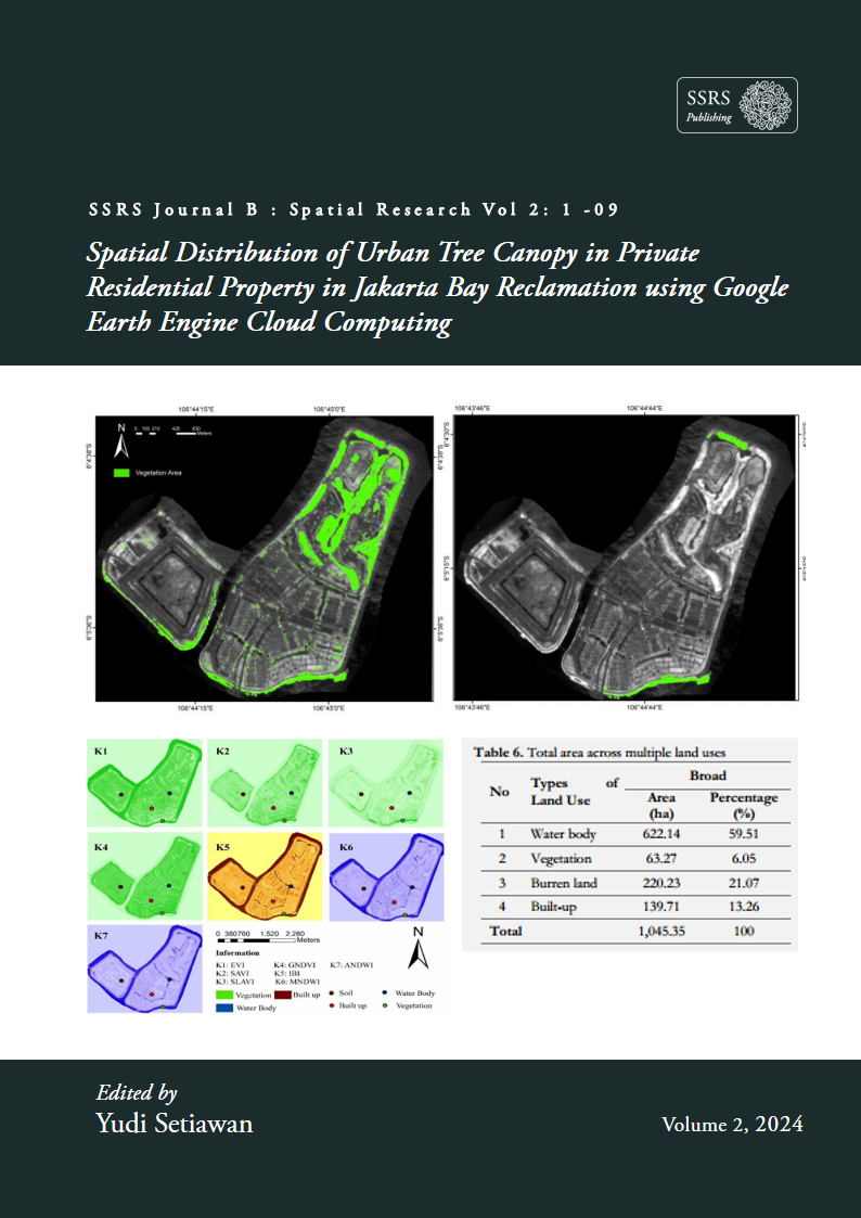
Jakarta Bay reclamation is a solution to Jakarta flood control and development of business units including property business. Reclamation was carried out with the construction of 18 small islands in front of the coastline and giant embankments. Pantai Indah Kapuk (one of the developers) has invested in the Jakarta Bay reclamation program with plans to build islands A, B, C, D, and E as residential and entertainment areas. However, until 2022 only Islands C and D were almost ready. Jakarta Bay Reclamation presents various threats, especially in terms of ecology. Pantai Indah Kapuk should have a green open space as an urban area. The purpose of this study was to look at the distribution of trees in the private residential property area of Pantai Indah Kapuk in the reclamation of Jakarta Bay C and D Islands. The research uses the Google Earth Engine Cloud Computing application with sentinel-2A image data source and classification by using several indexes to obtain the area of vegetation. The results showed that the classification area of water bodies, vegetation, land area, and buildings were 622.14 ha, 63.27 ha, 220.23 ha, and 139.71 ha, respectively. The accuracy test obtained an overall accuracy of 87.5% and a Kappa accuracy of 83.3%. The conclusion of this study is vegetation area in the private residential property area of Pantai Indah Kapuk covers 63.27 ha. The results of this study can be used as a basis for making reclamation management policies that prioritize ecological roles and functions to minimize negative impacts on the environment.

Unduhan

Diterbitkan

2024-10-06

Cara Mengutip

Raihan, F., Eka Nurhawaillah, L., Asy’Ari, R., Risky Pratama, O., Beatrix Alamako, W., Hajar Pudjawati, N., Saputra, R., Fauziyyah Adni, S., Putri Zamani, N., Pramulya, R., & Setiawan, Y. (2024). Spatial Distribution of Urban Tree Canopy in Private Residential Property in Jakarta Bay Reclamation using Google Earth Engine Cloud Computing. SSRS Journal B: Spatial Research, 2, 01–09. Diambil dari https://publishing.ssrs.or.id/ojs/index.php/ssrs-b/article/view/3