Mining Reclamation Monitoring using Sentinel-2 Temporal Data: Case Study in PT Adaro Energy Indonesia Mining Area
Kata Kunci:
Mining, Reclamation, Vegetation IndicesAbstrak
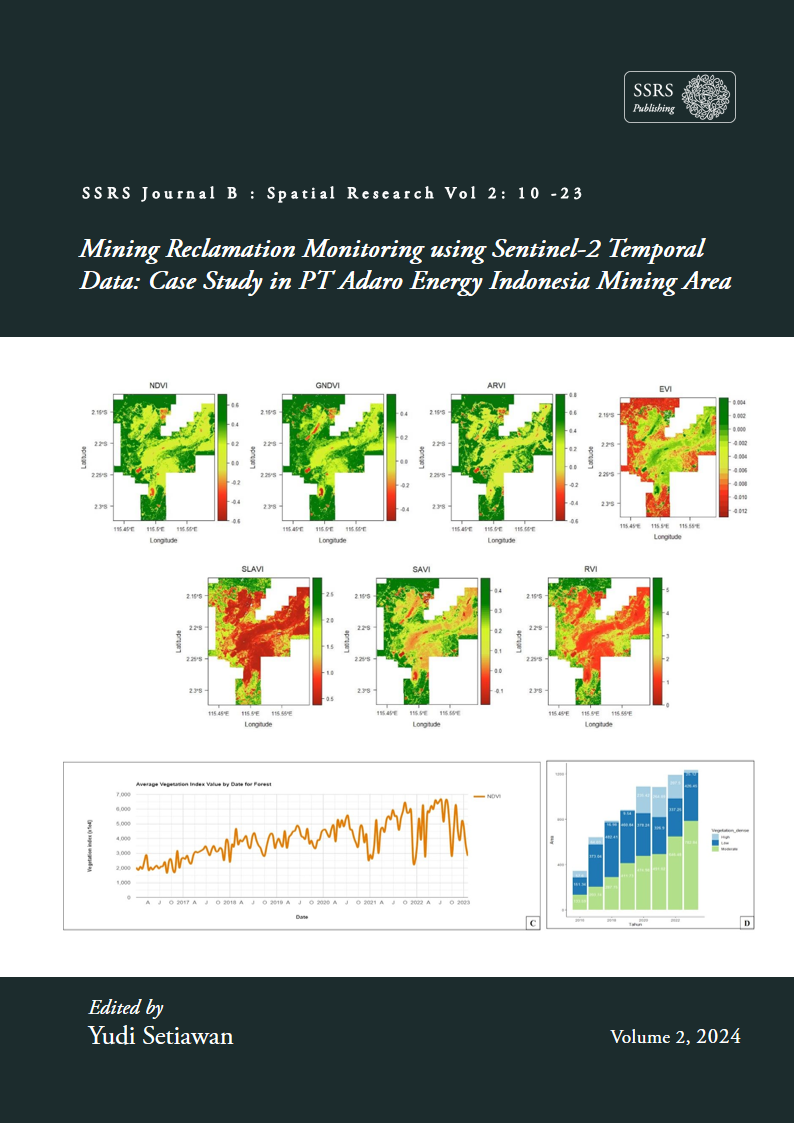
Indonesia is one of the countries that has a wealth of energy and mineral resources. However, mining activities carried out to exploit these mineral resources have a negative impact on ecosystems, especially forest ecosystems, so there is a need for ecosystem rehabilitation which is realized in the form of post-mining land reclamation. Along with the development of science and technology, remote sensing is a technology that can be used in monitoring revegetated land so that it has the potential to be developed in monitoring post-mining land reclamation land. This research aims to study the spectral characteristics of post-mining land in PT Adaro Energi Indonesia, Calculate the revegetation area from 2016 to 2023 and Map the results of PT Adaro Energi Indonesia's post-mining land reclamation spatiotemporally from 2016 to 2023. This research involves several vegetation indices in analyzing the spectral characteristics of land and monitoring the results of revegetation spasiotemporally from 2016 to 2023. The results of the spectral characteristics analysis show that RVI and SLAVI have the ability to distinguish vegetation density. Meanwhile, the results of spatiotemporal analysis show that ARVI has a fairly fluctuating pattern of increase while NDVI shows the opposite pattern in response to the increase in vegetation. During the period 2016 to 2023, PT Adaro's reclamation area experienced high revegetation from an initial 342.53 ha revegetated area, in 2023 the vegetated area increased to 1,234.41 ha. The results of this research show that PT Adaro Energi has successfully revegetated the post-mining land area. In addition, the use of remote sensing technology has the potential to be used in monitoring reclamation areas using vegetation indices and certain algorithms.