Understanding of Pest Species Distribution on Land Use, Geographic Location, and Climate Factor using Species Distribution Modelling: Case Study in Java Island, Indonesia
Keywords:
habitat suitability, SDM modeling, pest distribution, pest managementAbstract
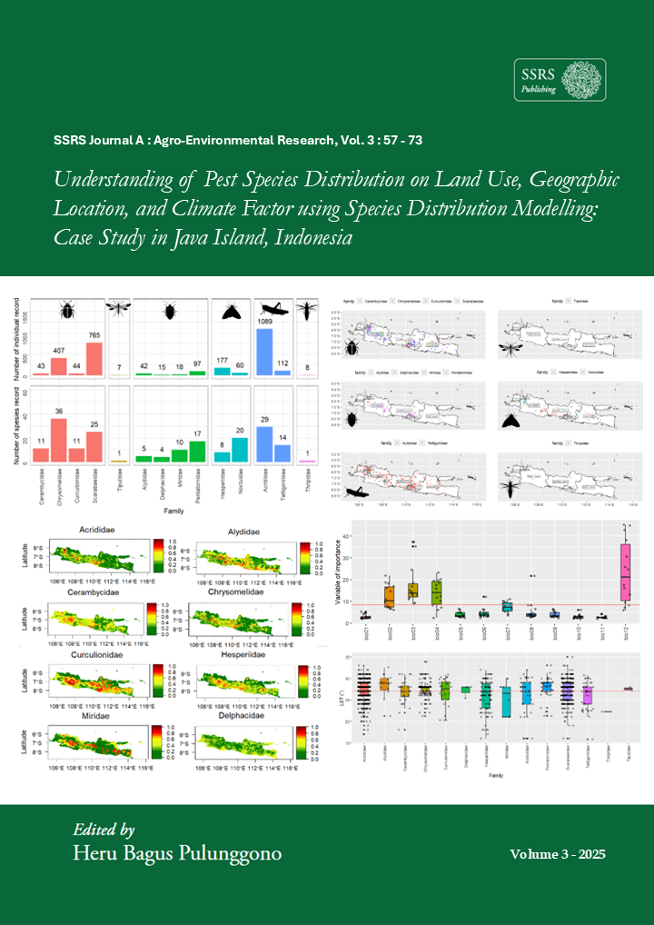
Pest distribution has a broad impact across sectors, including agriculture, plantations, and forestry. The impacts are predicted to continue to increase in the future, so understanding pest distribution patterns is important as a basis for more effective pest management decision-making. This study aims to analyze the distribution of pests in Java Island based on land use, geographical location, and climate factors. A total of 2,777 individuals from 14 pest families in GBIF citizen science data were analyzed using a machine-learning-based Species Distribution Modeling (SDM) approach to map habitat suitability. Modeling was conducted using 12 WorldClim bioclimate variables: temperature (bio1, bio2, bio4-bio11), thermal (bio3), and rainfall (bio12). Model accuracy was evaluated using two metrics: Area Under the Curve (AUC) and Kappa. The results showed that most pest families were distributed across three land-use types, with a dominance on agricultural land and at elevations below 500 meters above sea level. Land Surface Temperature (LST) data shows that pests are generally found at temperatures between 15°C and 35°C. Among all bioclimate variables analyzed, annual rainfall (bio12) has the highest influence on habitat suitability. The model performs well, with an average AUC of 0.88 and a Kappa of 0.64, indicating that the predicted pest distribution is accurate enough for pest management planning in the study area. Information on the spatial distribution and potential habitats is needed to target natural treatments.
Downloads
Published
How to Cite
Issue
Section
License
Copyright (c) 2025 Usnil Khotimah

This work is licensed under a Creative Commons Attribution 4.0 International License.