Spatiotemporal Platform for Assessing the Quality of Irrigated Paddy Soils in Cidadap Village, Subang Regency
Keywords:
Salinity, Soil quality, Paddy, Remote sensingAbstract
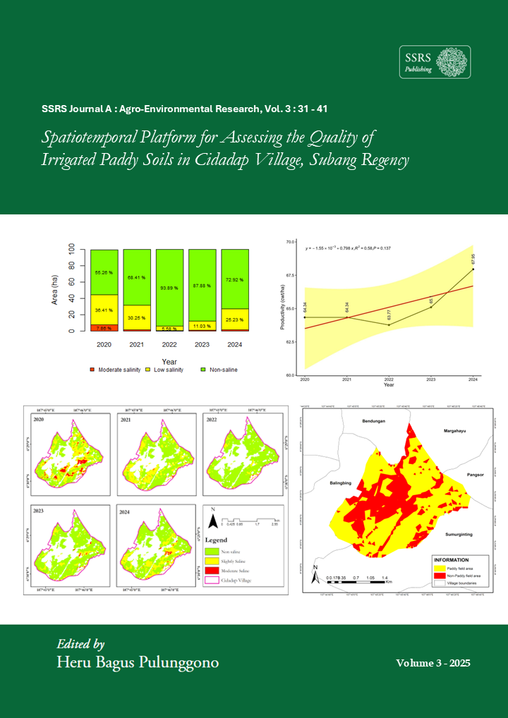
Indonesia is one of the world’s largest rice producers, with national rice production reaching 34.1 million tons. In order to maintain food security and support the national economy, soil quality plays a crucial role in sustaining agricultural productivity. Soil salinity is an important indicator affecting nutrient availability and plant growth. Increased salt content in paddy soils can inhibit water and nutrient uptake, leading to reduced rice yields, particularly in intensively managed irrigated paddy fields. Cidadap Village, Subang Regency, as an intensively cultivated agricultural area, experiences interannual fluctuations in soil salinity levels. The methods used in this study include irrigated paddy field detection through supervised classification using Landsat 8 OLI/TIRS imagery and estimation of electrical conductivity (EC) as a salinity indicator based on regression analysis with the Vegetation Soil Salinity Index (VSSI). All analyses were conducted on the Google Earth Engine (GEE) platform to support efficient and large-scale spatial data processing. Monitoring results indicate that salinity levels in irrigated paddy fields in Cidadap Village fluctuated during the 2020–2024 period, with EC values predominantly falling within the non-saline to low-salinity categories (1.8–3.6 dS/m), although several areas exhibited moderate salinity increases (>4 dS/m). These variations are influenced by hydrological conditions, rainfall, and irrigation water distribution. All spatial visualizations are presented through the Data Indo InaPad platform based on Earth Engine Apps as a practical and easily accessible tool for monitoring soil salinity conditions.
Downloads
Published
How to Cite
Issue
Section
License
Copyright (c) 2026 Hamid Ali Mukti

This work is licensed under a Creative Commons Attribution 4.0 International License.