Cloud Computing and Machine Learning Approach for Mangrove Mapping in Marine Protected Area (MPAs) of Banggai, Sulawesi Island Archipelago, Indonesia
Keywords:
Machine learning, mangrove, marine protected, BanggaiAbstract
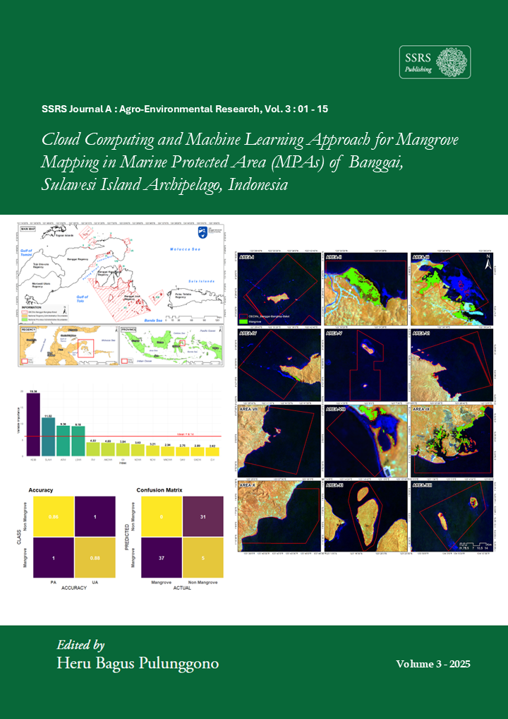
Mangroves are coastal forest ecosystems that serve multiple functions for coastal communities. Their ecological role as essential habitats for coastal and estuarine fauna, combined with their economic function as areas for fish production, makes mangrove ecosystems crucial for coastal and marine management. Unfortunately, within the context of sustainable fisheries, mangrove areas in Sulawesi remain underexplored, especially using satellite-based approaches. Therefore, this study focuses on quantifying the extent of mangroves within the Marine Protected Areas (MPAs) of Banggai – Banggai Kepulauan – Baggai Laut, Sulawesi Seascape. Utilizing a combination of Landsat-8 and Landsat-9 satellites through the Google Earth Engine (GEE) cloud computing platform, the mangrove mapping process incorporated machine learning techniques. In the MPAs of Banggai-Bangkep-Balut, mangroves were mapped covering an area of 5,323 hectares, approximately 0.62% of the total designated protected area. Mangrove detection using the two Landsat satellites achieved high accuracy levels, with an overall accuracy of 0.91 and a kappa statistic of 0.83. The error matrix indicated 6 misclassifications out of 73 validation points. These findings confirm the reliability of mangrove data within the Banggai MPAs management framework, supporting its use as blue carbon data to strengthen national emission reduction policies. In addition, cloud computing has proven to be excellent in extracting mangrove data in MPA areas and is highly recommended in future monitoring to create sustainable MPA governance.
Downloads
Published
How to Cite
Issue
Section
License
Copyright (c) 2025 Hidayat Arismunandar Katili, Abd. Malik A. Madinu, Khairani Putri Marfi, Verawati Ayu Lestari, Aulia Ulfa, Usnil Khotimah, Nurah Anggraeni, Danik Septianingrum, Nihawa Hajar Pudjawati, Ardya Hwardaya Gustawan, Azelia Dwi Rahmawati, Rahmat Asy’Ari, Ongky Ongky, Moh Zulfajrin, Diky Dwiyanto, Fahri Fahri, Mihwan Sataral, Yuni Rustiawati, Hasrudin Usman, Rahmat Pramulya, Yudi Setiawan, Neviaty Putri Zamani, Cecep Kusmana, Ferdy Salamat

This work is licensed under a Creative Commons Attribution 4.0 International License.