Agricultural and Fishery Activities on Mangrove Ecosystem Area, Bekasi Regency: Exploration Studies of Land Use Conditions in The Coastline Buffer Area

Authors

  • Azelia Dwi Rahmawati Graduate Student, Department of Forest Management, Faculty of Forestry and Environment, IPB University, Bogor Regency 16680, Indonesia https://orcid.org/0009-0005-4350-5062
  • Rahmat Asy'Ari SSRS EartInformatics Labs, SSRS Institute – SSRS Group, Bogor Regency, Indonesia https://orcid.org/0000-0001-7867-2251
  • Ali Dzulfigar Undergraduate Student, Department of Silviculture, Faculty of Forestry and Environment, IPB University, Bogor Regency 16680, Indonesia https://orcid.org/0009-0001-7900-8763
  • RA. Aulia Fitri Destia 4 Undergraduate Student, Faculty of Fisheries and Marine Sciences, IPB University, Bogor Regency, Indonesia
  • Rizkhy Ananda Undergraduate Student, Department of Aquatic Resources Management, Faculty of Fisheries and Marine Sciences, IPB University, Bogor Regency, Indonesia
  • Dedeh Faridah Undergraduate Student, Department of Forest Management, Faculty of Forestry and Environment, IPB University, Bogor Regency 16680, Indonesia
  • Julita Catri Adila Undergraduate Student, Department of Biology, Faculty of Mathematics and Natural Sciences, IPB University, Bogor Regency 16680, Indonesia
  • Lalita Mahardika Putri Firmansyah Undergraduate Student, Department of Biochemistry Faculty of Mathematics and Natural Sciences, IPB University, Bogor Regency 16680, Indonesia
  • Khairani Putri Marfi Undergraduate Student, Department of Silviculture, Faculty of Forestry and Environment, IPB University, Bogor Regency 16680, Indonesia https://orcid.org/0009-0006-8713-2031
  • Raditya Febri Puspitasari Undergraduate Student, Department of Biology, Faculty of Forestry and Environment, IPB University, Bogor Regency 16680, Indonesia
  • Aulia Ulfa Undergraduate Student, Department of Biology, Faculty of Mathematics and Natural Sciences, IPB University, Bogor Regency 16680, Indonesia https://orcid.org/0009-0001-8739-8845
  • Sylva Puspita Undergraduate Student, Department of Forest management, Faculty of Forestry and Environment, IPB University, Bogor Regency 16680, Indonesia
  • Ardya Hwardya Gustawan Graduate Student, Department of Forest management, Faculty of Forestry and Environment, IPB University, Bogor Regency 16680, Indonesia
  • Fathan Aldi Rivai Graduate Student, Department of Soil Science and Land Resources, Faculty of Agriculture, IPB University, Bogor Regency 16680, Indonesia
  • Muhammad Hisyam Fadhil Undergraduate Student, Department of Agronomy and Horticulture, Faculty of Agriculture, IPB University, Bogor Regency 16680, Indonesia https://orcid.org/0000-0002-6329-8612
  • Neviaty Putri Zamani Center for Transdisciplinary and Sustainability Sciences (CTSS), IPB University, Bogor Regency 16680, Indonesia https://orcid.org/0000-0001-7687-9443
  • Rahmat Pramulya Research Center for Low Carbon Development, University of Teuku Umar, Aceh, Indonesia https://orcid.org/0000-0001-8569-7203
  • Yudi Setiawan Center for Environmental Research, IPB University, Bogor Regency 16680, Indonesia https://orcid.org/0000-0002-1482-1905

Keywords:

Land Use, SVM-ML, Mangrove Ecosystem, Bekasi Coastline Buffer Area

Abstract

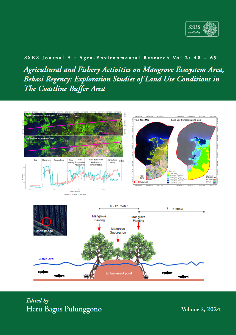
As a country with the widest mangrove forest area in the world, Indonesia has potential and challenges in preserving the mangrove ecosystem. Bekasi Regency is an area with a mangrove ecosystem that has experienced degradation, so research needs to be conducted to monitor the mangrove area and uncover land use by coastal communities. This research uses field data (including agricultural and fishing activities) in mangrove forest area in Bekasi Coastline Buffer Area, and remote sensing data from Sentinel-2 MultiSpectral Instrument (MSI) satellite data. In process analysis, using machine learning (ML) algorithm is the Support Vector Machine (SVM) and through in the advanced GEE computing platform. The analysis involves 11 indices consisting of vegetation indices, namely NDI, MNDVI, SAVI, SLAVI, and ARVI; water indices, namely NDWI, LSWI, and ANDWI; and building indices, namely IBI. The results of mangrove mapping obtained an area of ​​836.91 ha or equivalent to 6.57% of the area of ​​Bekasi Regency and the Overall Accuracy (OA) results reached 90%, and Kappa Statistics (KS) were 0.8. The mapped mangrove areas have great potential in various aspects, especially playing a role in controlling land erosion, protecting against atmospheric disasters, and also contributing to controlling climate change.  The silvofishery area which is a balance between mangroves and ponds, has great potential in sustainable land use and coastal ecosystem restoration.This research is expected to encourage policymakers to become one of the strategic policy supports that can quickly restore the mangrove ecosystem, thus controlling the threat of sea-level inundation that adds to the vulnerability area every year.

Downloads

Published

2024-10-06

How to Cite

Rahmawati, A. D., Asy’Ari, R., Dzulfigar, A., Destia, R. A. F., Ananda, R., Faridah, D., Adila, J. C., Firmansyah, L. M. P., Marfi, K. P., Puspitasari, R. F., Ulfa, A., Puspita, S., Gustawan, A. H., Rivai, F. A., Fadhil, M. H., Zamani, N. P., Pramulya, R., & Setiawan, Y. (2024). Agricultural and Fishery Activities on Mangrove Ecosystem Area, Bekasi Regency: Exploration Studies of Land Use Conditions in The Coastline Buffer Area. SSRS Journal A: Agro-Environmental Research, 2, 48–69. Retrieved from https://publishing.ssrs.or.id/ojs/index.php/ssrs-a/article/view/21