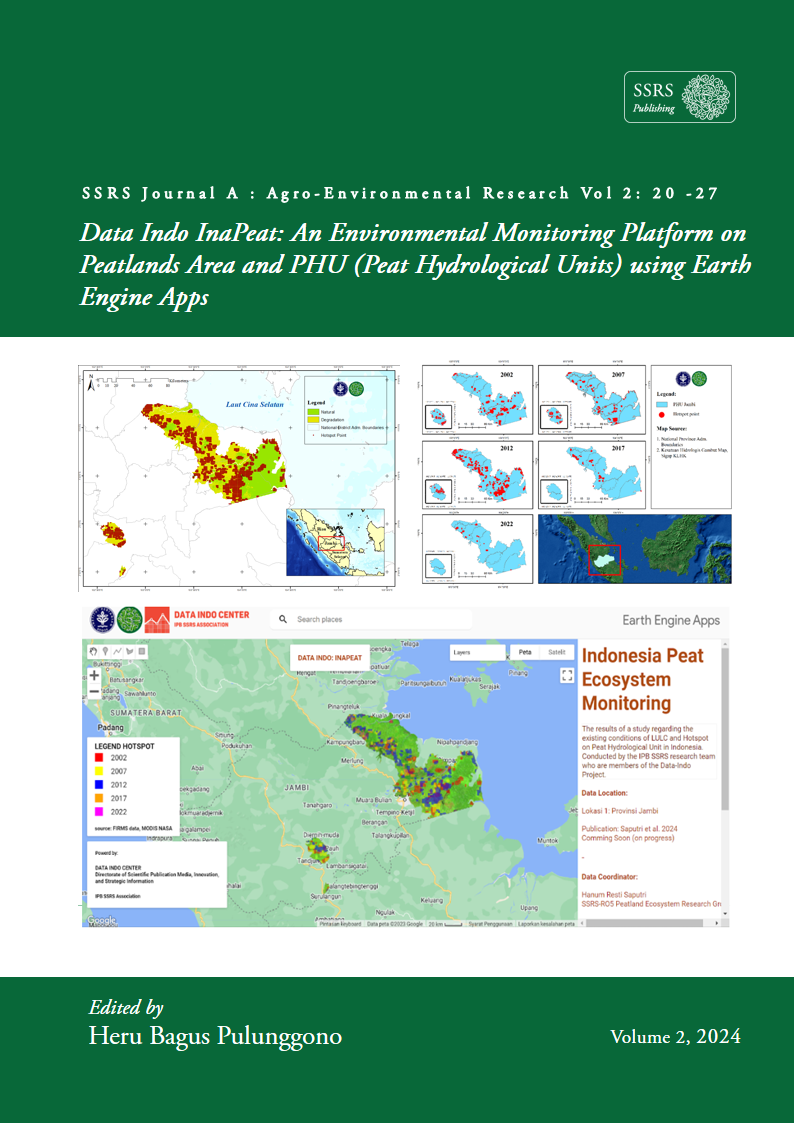
Data Indo InaPeat: An Environmental Monitoring Platform on Peatlands Area and PHU (Peat Hydrological Units) using Earth Engine Apps
Keywords:
FIRMS MODIS, Hotspot, KHG, Landsat 9 OLI/TIRS, PeatlandAbstract
Peat is one of the wetland ecosystems in Indonesia which is often damaged due to unsustainable human intervention. This causes fires in peatlands, thereby eliminating ecological functions which are characterized by changes in land cover. The protection of peat ecosystems in Indonesia relies on hydrological aspects, namely the Peat Hydrological Unit (PHU) to maintain the Ground Water Levels (GWL) to minimize the potential for forest and peat land fires. This research aims to develop the DATAINDO InaPeat platform for monitoring PHU ecosystems in Jambi Province based on changes in land cover and hotspot distribution from 2002 to 2022. Data analysis was carried out by identifying the distribution of hotspots for each type of land cover. Hotspot and land cover data were obtained through the Moderate Resolution Imaging Spectroradiometer (MODIS) Fire Information for Resource Management System (FIRMS) and Landsat 9 OLI 2-TIRS2 imagery imported from the Google Earth Engine (GEE) dataset. The land cover classification was carried out using guided classification in 2021-2023. There are two types of classification used, namely classification to assess the condition of peatland damage (degraded and natural areas) and land cover (swamps, swamp forests, open land, plantations, mixed plantations, settlements, and water bodies). Based on the data analysis, the distribution of hotspots that dominated natural areas was 940 hotspots in 2002, 731 hotspots in 2007, and 651 hotspots in 2012, meanwhile, in degraded areas, 279 and 152 points in 2017 and 2022, respectively. This shows that hotspots caused damage to peatlands, thereby increasing the degraded area to 63.73% of the total PHU area of 874,951.7 ha. These were caused by the opening of oil palm plantations which can reduce GWL, thus potentially triggering forest and peatland fires. Data on hotspots and degraded areas that have been recorded are displayed on the Earth Engine Apps platform in the form of DATAINDO InaPeat. It is hoped that the use of this monitoring platform can become a tool for monitoring the physical condition of peat ecosystems and supporting the sustainable use of peatlands in Indonesia.
Downloads
Published
How to Cite
Issue
Section
License
Copyright (c) 2024 Hanum Resti Saputri, Izzah Aulia Inanda, Intan Nur Rahmadhanti, Rahmat Asy'Ari, Muhammad Hisyam Fadhil, Salsa Fauziyyah Adni, Fajar Raihan, Erianto Indra Putra, Yudi Setiawan, Rahmat Pramulya, Neviaty Putri Zamani

This work is licensed under a Creative Commons Attribution 4.0 International License.