Spatio-temporal analysis of Mangroves in Subang Regency using Sentinel-2 TimeSeries Data

Authors

  • Ali Dzulfigar Undergraduate Student, Department of Silviculture, Faculty of Forestry and Environment, IPB University, Bogor Regency 16680, Indonesia https://orcid.org/0009-0001-7900-8763
  • Rahmat Asy'Ari IPB Sustainable Science Research Student Association (IPB SSRS Association), IPB University, Bogor Regency 16680, Indonesia https://orcid.org/0000-0001-7867-2251
  • Azelia Dwi Rahmawati Graduate Student, Department of Forest management, Faculty of Forestry and Environment, IPB University, Bogor Regency 16680, Indonesia https://orcid.org/0009-0005-4350-5062
  • Aulia Ulfa Undergraduate Student, Department of Biology, Faculty of Forestry and Environment, IPB University, Bogor Regency 16680, Indonesia https://orcid.org/0009-0001-8739-8845
  • Khairani Putri Marfi Undergraduate Student, Department of Silviculture, Faculty of Forestry and Environment, IPB University, Bogor Regency 16680, Indonesia https://orcid.org/0009-0006-8713-2031
  • Raditya Febri Puspitasari Undergraduate Student, Department of Biology, Faculty of Forestry and Environment, IPB University, Bogor Regency 16680, Indonesia
  • Sylva Puspita Undergraduate Student, Department of Forest management, Faculty of Forestry and Environment, IPB University, Bogor Regency 16680, Indonesia
  • Julita Catri Adila Undergraduate Student, Department of Biology, Faculty of Forestry and Environment, IPB University, Bogor Regency 16680, Indonesia
  • Lalita Mahardika Putri Firmansyah Undergraduate Student, Department of Biochemistry, Faculty of Forestry and Environment, IPB University, Bogor Regency 16680, Indonesia
  • Neviaty Putri Zamani Department of Marine Science and Technology, Faculty of Fisheries and Marine Science, IPB University, Bogor Regency, 16680, Indonesia https://orcid.org/0000-0001-7687-9443
  • Rahmat Pramulya Research Center for Low Carbon Development, University of Teuku Umar, Aceh, Indonesia https://orcid.org/0000-0001-8569-7203
  • Yudi Setiawan Center for Environmental Research, IPB University, Bogor Regency 16680, Indonesia https://orcid.org/0000-0002-1482-1905

Abstract

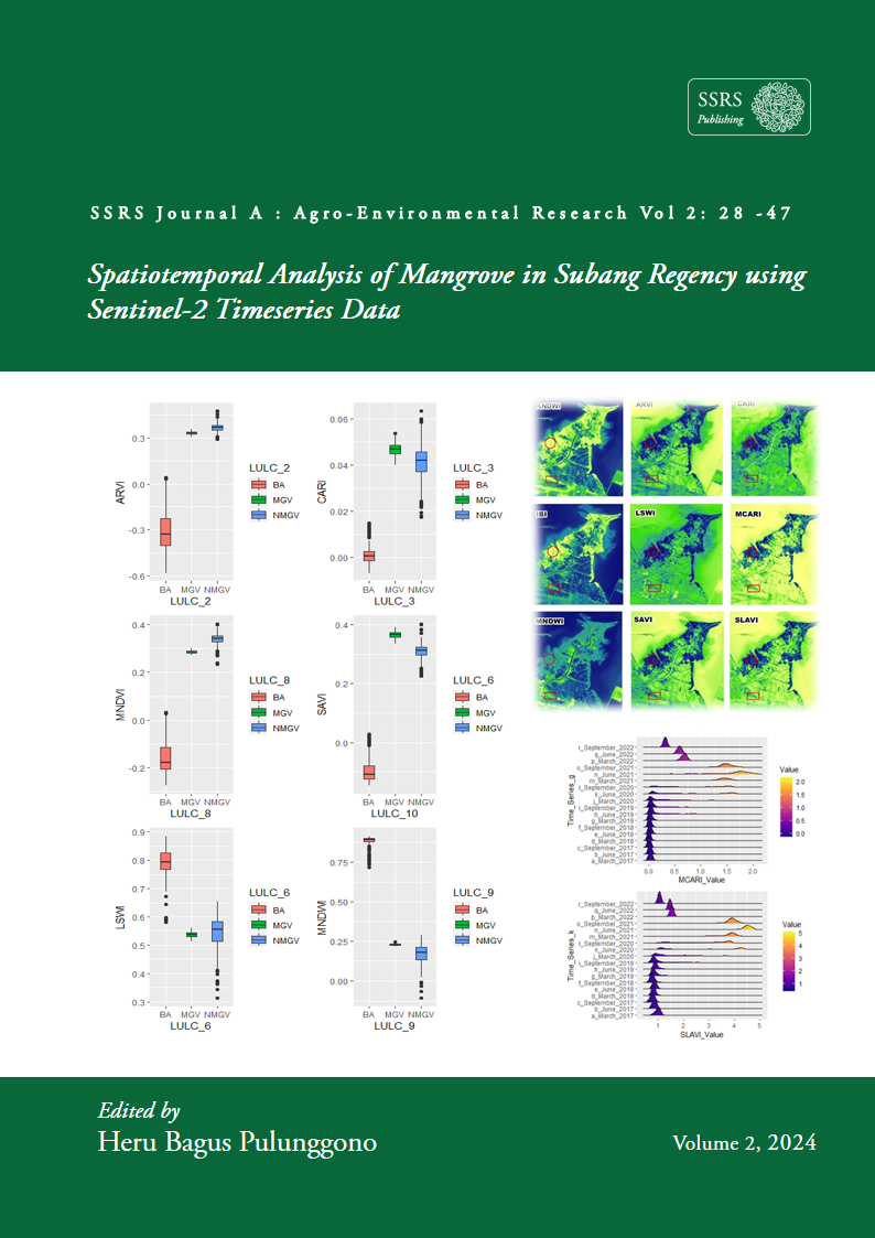
The mangrove forest ecosystem is one of the types of ecosystems that grow in the tidal areas of the ocean and play an essential role in addressing global issues such as climate change. Remote sensing technology can be used to monitor mangrove areas accurately and efficiently. This study aims to detect the spatiotemporal distribution of mangroves from 2017 to 2022 using remote sensing techniques, identify the spectral characteristics and threshold values of the indices involved in mangrove area detection, and determine the accuracy of mangrove area detection in Subang Regency, West Java. Mangrove area detection is carried out using Land Use Land Cover (LULC) classification involving several vegetation, water, and built-up indices to obtain the mangrove area from 2017 to 2022. The research results showed that the mangrove area was 1972.98 ha and distributed in areas A, B, C, and D. Area D showed an increase in mangrove area due to natural succession or planting.The spectral vegetation index tends to increase while the water index and built-up index tend to decrease. MNDWI has the ability to distinguish between mangrove and non-mangrove vegetation. The research results show that there are examples of mangrove succession points (area D) which can be used as a consideration for policy-making to optimize the role and function of mangroves as a natural barrier.

Downloads

Published

2024-10-06

How to Cite

Dzulfigar, A., Asy’Ari, R., Rahmawati, A. D., Ulfa, A., Marfi, K. P., Puspitasari, R. F., Puspita, S., Adila, J. C., Firmansyah, L. M. P., Zamani, N. P., Pramulya, R., & Setiawan, Y. (2024). Spatio-temporal analysis of Mangroves in Subang Regency using Sentinel-2 TimeSeries Data. SSRS Journal A: Agro-Environmental Research, 2, 28–47. Retrieved from https://publishing.ssrs.or.id/ojs/index.php/ssrs-a/article/view/18