Mapping Ecotourism Suitability Zones and Potential: A Case Study Using Remote Sensing Geospatial Information in Bogor Regency
Keywords:
Ecotourism, Geoenvironmental, GeospatialAbstract
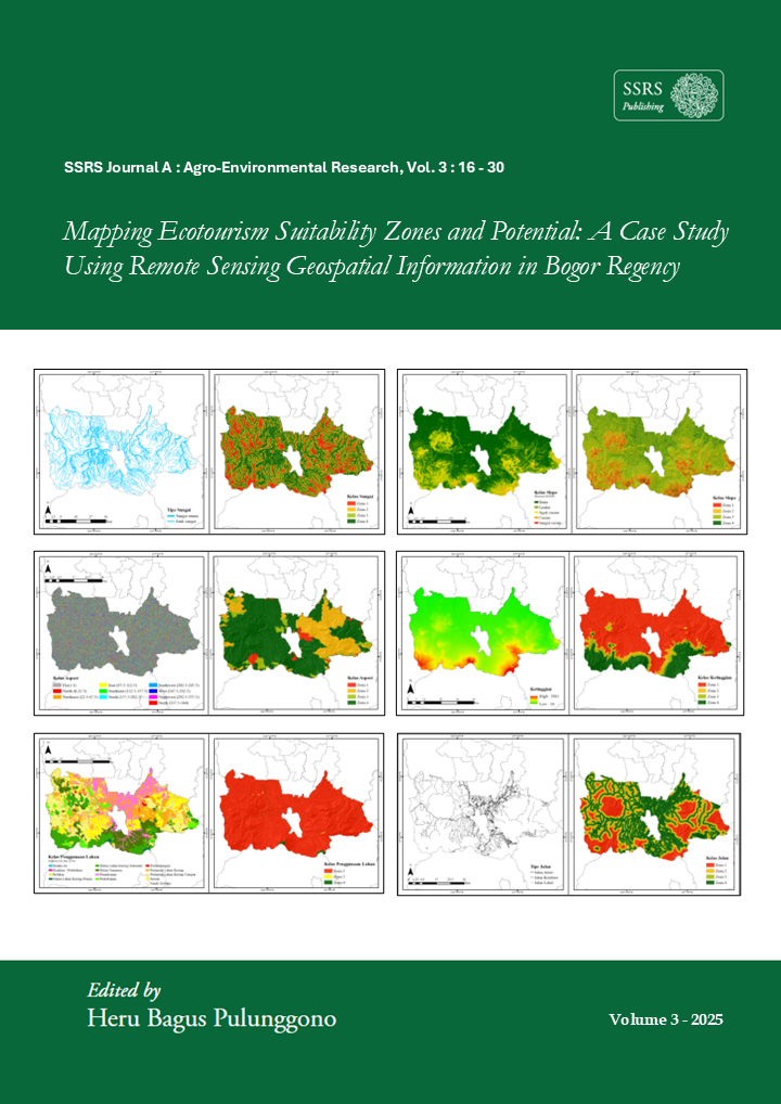
Over the past few decades, the trend toward sustainable development globally has increased, and there are many cases of development that has a negative impact on the environment. The ecotourism scheme is one of the answers that can be used to reconcile economic development with aspects of environmental sustainability. Along with the increasing use of ecotourism schemes, of course, the provision of adequate infrastructure is fundamental to running the scheme. This research aims to map ecotourism suitability zones in Bogor Regency based on a geoecotourism model obtained through the integration of various remote sensing geospatial information. The model can produce an integrated landscape component analysis consisting of distance from water bodies, land use, distance from roads, distance from settlements, aspect, slope, and elevation. The results of the analysis are grouped into four classification zones according to their ecotourism potential, namely low, medium, high, and very high ecotourism potential zones. Based on the classification of the ecotourism potential zone, the direction of infrastructure development in each zone is determined to maximize the ecotourism scheme that is carried out. The results of this study are expected to provide recommendations to the Bogor Regency Tourism Office regarding the provision of appropriate infrastructure in various ecotourism zones in Bogor Regency and implement the Society 5.0 concept in Indonesia.
Downloads
Published
How to Cite
Issue
Section
License
Copyright (c) 2026 Dedeh Faridah, Muhammad Arya Duta Hidayat, Ali Dzulfigar, Lenny Eka Nurhawaillah, Rahmat Asy’Ari, Yudi Setiawan, Neviaty P Zamani, Rahmat Pramulya

This work is licensed under a Creative Commons Attribution 4.0 International License.